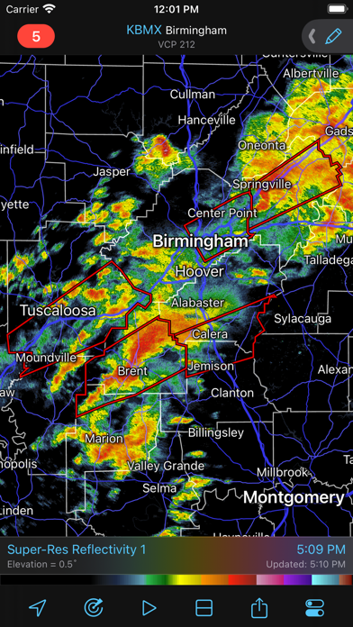
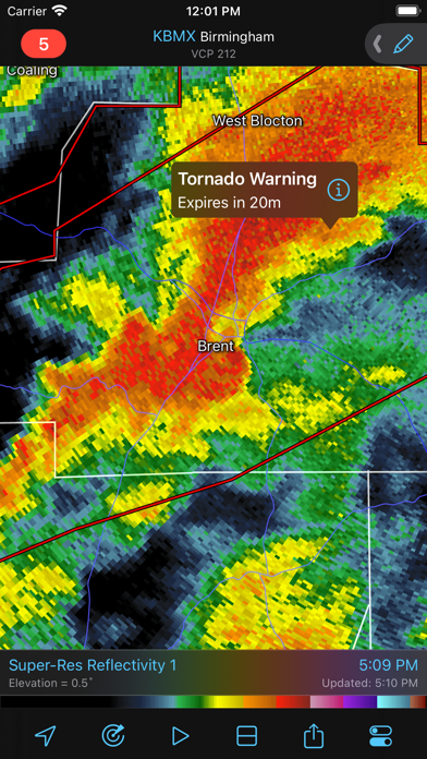
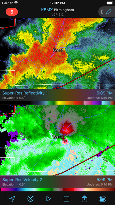
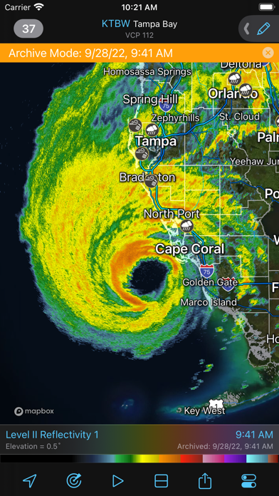
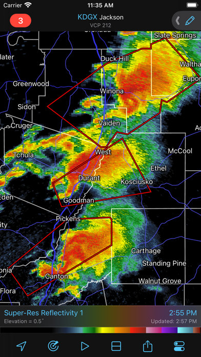
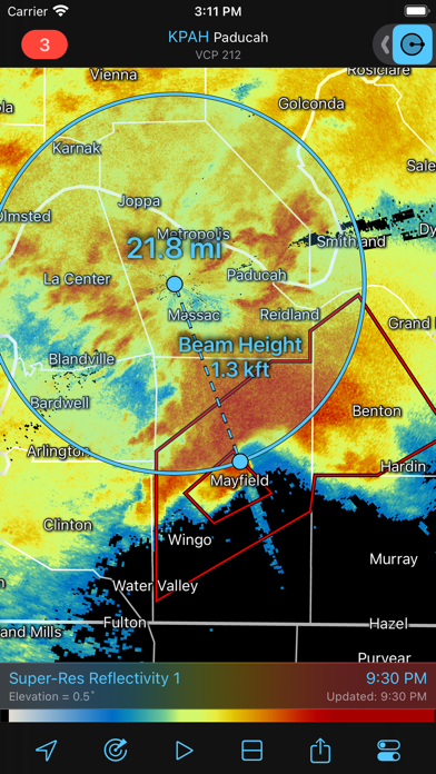
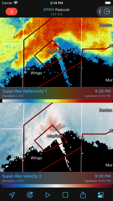
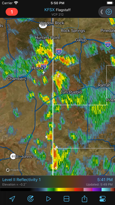
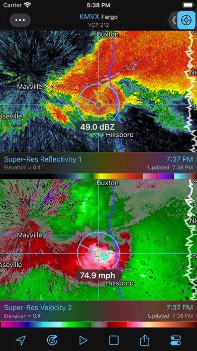
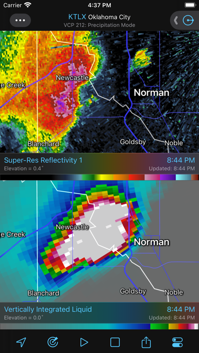
RadarScope is a specialized display utility for weather enthusiasts and meteorologists that allows you view NEXRAD Level 3 and Level 2 radar data along with tornado, severe thunderstorm, flash flood, special marine and snow squall warnings, and predicted storm tracks issued by the U.S. National Weather Service. It can display the latest reflectivity, velocity, dual-polarization, and other products from any NEXRAD or TDWR radar site in the United States, Guam, Puerto Rico, Korea, and Okinawa, as well as data from Environment Canada, Australian Bureau of Meteorology, Finnish Meteorological Institute, and German Weather Service radars. These aren't smoothed images, this is native radar data rendered in its original radial format for a high level of detail. Whether you are scanning reflectivity for a mesocyclone's tell-tale hook echo, trying to pinpoint the landfall of a hurricane's eye wall, or looking for small features like velocity couplets in the storm relative radial velocity product, RadarScope gives you the power to view true radial weather radar data. RadarScope displays tornado, severe thunderstorm, flash flood, special marine, and snow squall warnings issued by the U.S. National Weather Service. You can browse the list of active warnings, select a warning to view the details, and even zoom to the selected warning on the map. Pinch or stretch to zoom in and out. Drag your finger around the map to scroll. Tap the radar sweep button in the toolbar to switch radars. Select one of the 289 different radars in the United States, Canada, Australia, Germany, Korea, Puerto Rico, Guam, or Okinawa. Plot your current location by tapping the location button and optionally report it to the Spotter Network. Tap the play button to download and animate over recent images. Display the names of over 25,000 cities and towns on the map as you zoom and scroll. Tap and hold the color legend to see the data values. Meanwhile, RadarScope will retrieve and display updated data automatically and intelligently (approximately every 2 to 10 minutes, depending on the radar scan strategy). You can display radar data from our servers, NOAA's public access web site, or your Allison House subscriber account. Spotter Network members can report their location and view the locations of other spotters. RadarScope Pro is an optional auto-renewing subscription with two different tiers to choose from. RadarScope Pro Tier One is an annual subscription that provides access to real-time animated lightning data and up to 30 frames of radar data, including extended loops of super-resolution data. Tier One subscribers can also access a data interrogation tool to quickly determine data values for specific radar pixels and an optional dual-pane mode for viewing two radar products side-by-side. RadarScope Pro Tier Two is an annual or monthly subscription that combines all the features in Tier One with more advanced features, including 50-frame loops, SPC outlooks, special weather statements, mesoscale discussions, local storm reports, hail size and probability contours, and azimuthal shear contours in the U.S., a 30-day archive of all radar products, a 2-year archive of NEXRAD Level 3 radar products, a full historical archive of NEXRAD Level 2 products, and the ability to use subscription features across multiple platforms. If you choose to buy the RadarScope Pro subscription, it will charged to your iTunes account. The subscription will be auto-renewed within 24 hours prior to the end of the current period at the same price you originally paid. Subscriptions may be managed and auto-renewal disabled via your iTunes Account Settings after the purchase. Once purchased, the subscription cannot be cancelled during the active subscription period. DTN is committed to safeguarding your privacy online. Our privacy policy is available for review at: https://www.dtn.com/privacy-policy/ Please visit our web site for more information.